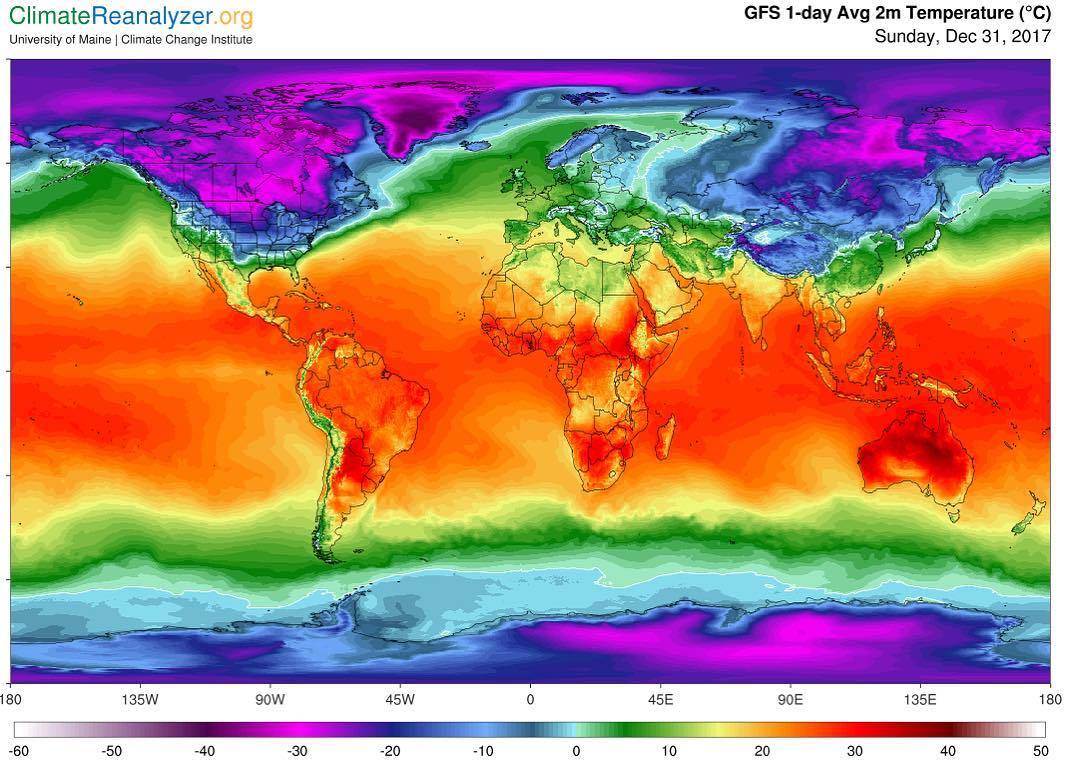
How the last day of 2017 feels depends on where you live.
Happy New Year!
Tags:
#weather #pretty things #sounds about right #(huh western Europe is warm)
How the last day of 2017 feels depends on where you live.
Happy New Year!
Tags:
#weather #pretty things #sounds about right #(huh western Europe is warm)
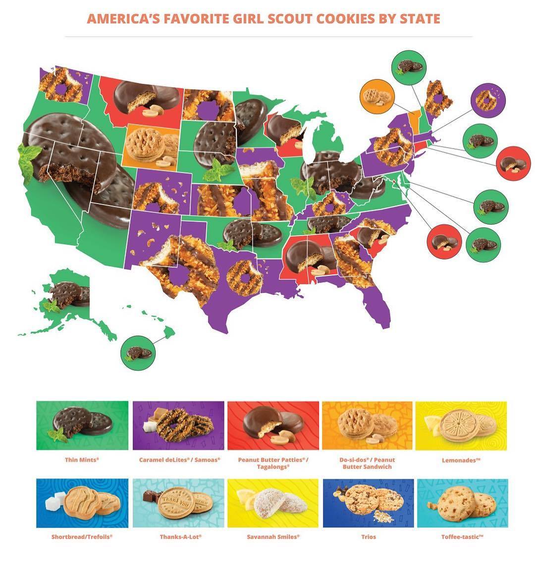
Favorite Girl Scout cookies, by state. Seeing this, my state is hungry.
Tags:
#…since when is New Jersey’s favorite Girl Scout cookie not Thin Mint #has something changed in the past ten years? #(okay things clearly *have* changed because I don’t recognise like half of these but still) #does North Jersey love Samoas enough to outweigh South Jersey’s love of Thin Mints? #(Samoas were pretty popular but not *Thin-Mint*-level popular) #home of the brave #food #Girl Scouts
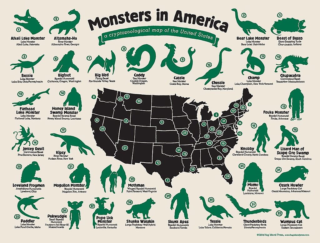
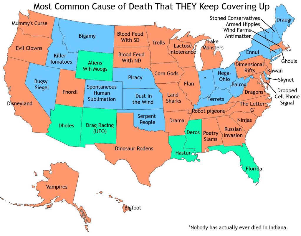
[1200×912] Map of cryptozoological creatures for most of America’s regions
CLICK HERE FOR MORE MAPS!
thelandofmaps.tumblr.comYou should all move to the Midwest! We’re certified monster free!
DC: Congress.
Tags:
#home of the brave #so basically a lot of humans and plesiosaurs is what I’m getting from this #and also that I have still not forgiven my fellow Girl Scouts for ignoring me when I asked to be brought up to speed on this ‘Jersey Devil’ #instead just continuing on with their at best semi-penetrable conversation #about how we were in a cabin in the middle of the Pine Barrens and *anything* could *happen* #anything except learning what the fucking Jersey Devil is
I like California, Alaska and Florida
funereal-disease perhaps you should consider moving to Kentucky.
[checks map] Time to move to Indiana! I like their track record.
Tags:
#anything that makes me laugh this much deserves a reblog #(Florida) #death tw
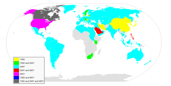
Day-Month-Year makes the most sense to me, smallest to largest. How about you?
Tags:
#our home and cherished land #fucking Canada man #just pick one #I don’t care which just fucking pick one #in which Brin has a food poisoning phobia #and thus has Feelings about expiration date ambiguity
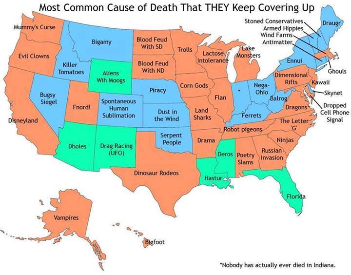
Most common cause of death in Georgia is Russian invasion…
See Ursula? It is NOT Mothman in WVa
Mothman strongly resembles a small Balrog. I think they’ve just confused their taxonomy.
Mothman doesn’t cause death – he merely presages it! Gosh
Oh no! I will not take by swayed by Moth-apologists! Mothman shows up, people die! The first few times, okay, sure, maaaaybe it’s a coincidence, but once the bridges start falling down, it’s Mothpocalypse Now!
Typhoid Mary thought she was just unlucky, too, but she was directly responsible. When will the world learn that If Mothman does not wash his hands before preparing food….
…wait, I think I got confused there. Um.
Moral of the Story: Mothman Should Not Cater Your Child’s Birthday Party For Multiple Reasons.
Tags:
#anything that makes me laugh this much deserves a reblog
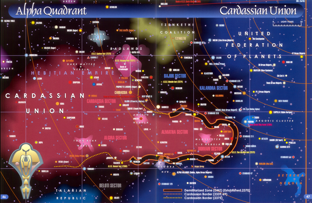
Staring at Star Trek maps TO FIGURE OUT WHERE THE FUCK EVERYTHING IS
(from this blog )
If you flip the Cardassian symbol on its side, it actually kinda looks like the shape of the Cardassian union!
While not perfect, this book (“Star Trek: Star Charts”) is just so full of yummy awesomeness in a fanboy way. Cause finally, you could make more sense of the Trek universe than ever before. Even if some choices didn’t make any sense or something contradicted itself. The maps have since been adopted by pretty much anyone/everyone when needed.
I even re-created this one with some heavy modifications for a never-got-off-the-ground PBEM RPG I was going to do.
Star Trek Online used these as a source, I think. Well, until they went to the Delta Quadrant and decided to compress 7 years and 70,000 light years into 2 sector grids of 3 sectors each… :S
It’s nice knowing where stuff is though. It gives it… dimension?
Tags:
#Star Trek #DS9 #interesting
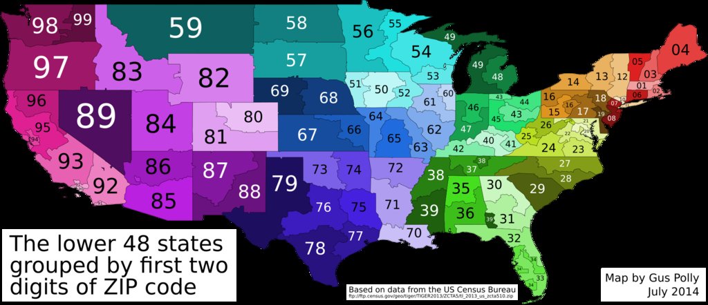
[OC] The US grouped by first two ZIP code digits [1920×828]
CLICK HERE FOR MORE MAPS!
thelandofmaps.tumblr.com
In case you were wondering, Hawaii is part of 96, Alaska is part of 99, and Puerto Rico is part of 00.
Tags:
#why don’t I have an America tag #I’m certain I’ve reblogged stuff about America before #oh well I can start now #maybe retroactively tag stuff later #should probably be something to go with my Canada tag #I guess that would make it #home of the brave #(which sounds a little less complimentary when you consider what a total coward I am) #(and how I often wonder why people don’t show a little more self-preservation) #anyway I always kind of wondered about this when I was a kid living in 08 #the more you know #tag rambles
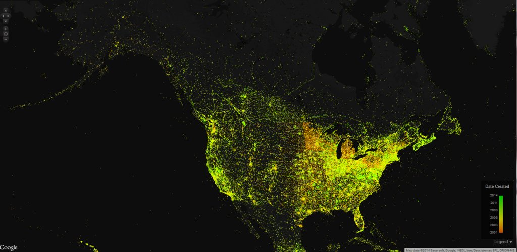
Map of Wikipedia articles by date of creation [1655×808]
CLICK HERE FOR MORE MAPS!
thelandofmaps.tumblr.com
Tags:
#Wikipedia #maps #pretty things
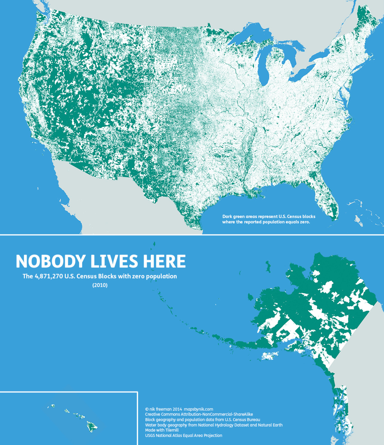
Nobody lives here: The nearly 5 million Census Blocks with zero population
A Block is the smallest area unit used by the U.S. Census Bureau for tabulating statistics. As of the 2010 census, the United States consists of 11,078,300 Census Blocks. Of them, 4,871,270 blocks totaling 4.61 million square kilometers were reported to have no population living inside them. Despite having a population of more than 310 million people, 47 percent of the USA remains unoccupied.
Green shading indicates unoccupied Census Blocks. A single inhabitant is enough to omit a block from shading
Map observations
The map tends to highlight two types of areas:
- places where human habitation is physically restrictive or impossible, and
- places where human habitation is prohibited by social or legal convention.
Water features such lakes, rivers, swamps and floodplains are revealed as places where it is hard for people to live. In addition, the mountains and deserts of the West, with their hostility to human survival, remain largely void of permanent population.
Of the places where settlement is prohibited, the most apparent are wilderness protection and recreational areas (such as national and state parks) and military bases. At the national and regional scales, these places appear as large green tracts surrounded by otherwise populated countryside.
At the local level, city and county parks emerge in contrast to their developed urban and suburban surroundings. At this scale, even major roads such as highways and interstates stretch like ribbons across the landscape.
Perhaps the two most notable anomalies on the map occur in Maine and the Dakotas. Northern Maine is conspicuously uninhabited. Despite being one of the earliest regions in North America to be settled by Europeans, the population there remains so low that large portions of the state’s interior have yet to be politically organized.
In the Dakotas, the border between North and South appears to be unexpectedly stark. Geographic phenomena typically do not respect artificial human boundaries. Throughout the rest of the map, state lines are often difficult to distinguish. But in the Dakotas, northern South Dakota is quite distinct from southern North Dakota. This is especially surprising considering that the county-level population density on both sides of the border is about the same at less than 10 people per square mile.
Finally, the differences between the eastern and western halves of the contiguous 48 states are particularly stark to me. In the east, with its larger population, unpopulated places are more likely to stand out on the map. In the west, the opposite is true. There, population centers stand out against the wilderness.
::
Ultimately, I made this map to show a different side of the United States. Human geographers spend so much time thinking about where people are. I thought I might bring some new insight by showing where they are not, adding contrast and context to the typical displays of the country’s population geography.
I’m sure I’ve all but scratched the surface of insight available from examining this map. There’s a lot of data here. What trends and patterns do you see?
::
©mapsbynik 2014
Creative Commons Attribution-NonCommercial-ShareAlike
Block geography and population data from U.S. Census Bureau
Water body geography from National Hydrology Dataset and Natural Earth
Made with Tilemill
USGS National Atlas Equal Area Projection
Tags:
#maps #neat #(the following category tag was added retroactively:) #home of the brave
