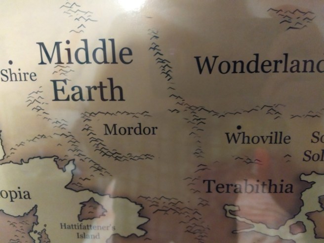
One of my favorite hobbies is thinking about the fucked up implications of this fantasy world map my parents got me for christmas
[Image ID: photo of a map. On the left side of the map is Middle Earth, with the Shire and Mordor labeled. To the direct right of Mordor is Whoville.]
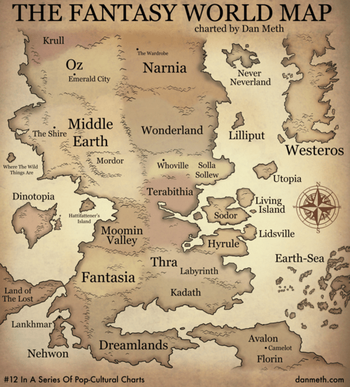
I FOUND THE FULL ONE AND ITS SO MUCH MORE CHAOTIC.
HYRULE SHOOK ME TO MY CORE!
THIS WORD HAS TWO KINGDOMS RULES BY A BEING IN A TOWER!
The existence of Oz and Neverland is wild too. Does this mean that there is a REAL Earth outside of this? Could Wendy hang out in Westeros?
Where the wild things are: the destroyed isle of Numenor????????
I was going to point out Numenor but I just realized Westeros is Aslan’s Country and I cannot stop laughing
Tags:
#maps #juxtaposition #I didn’t actually laugh aloud but it still amused me enough to reblog #this probably deserves some warning tag but I am not sure what
go to this random coordinates generator and say in the tags how you would fare if you were dropped where it generates without warning. i’ll go first i’d be dropped in the middle of the fucking south atlantic ocean and perish
I got one of those dinky little islands near the Canada-Alaska border! Total crapshoot whether I freeze to death before I find a human who’ll let me hitchhike somewhere.
Tags:
#latitude 33.54180 longitude -167.46516 #middle of goddamn nowhere roughly a thousand kilometres north of some tiny Hawaiian island #on my fifth attempt I hit land‚ in a field fifteen metres from a highway in Vietnam #(12.015250 108.135528) #I can probably work with that one #especially if I get dropped with my utility belt #(oh wow‚ WolframAlpha gives lots of neat fun facts about a coordinate point if you search for it) #(did you know that‚ while it’s merely 28C in temperature‚ the current UV index there is *13*?) #(I didn’t even know the UV index *went* that high) #(WolframAlpha helpfully informs me that very pale people such as myself should not be outside for more than 10 minutes) #(I still think I can probably make it work overall but it looks like I’m in for a nasty sunburn) #((at least on whatever parts I wasn’t able to cover up: I think I do have a *little* tube of sunscreen in my bag)) #((…wait‚ hang on‚ the weather station they’re pulling this from is *208km* away from and *640* metres below the actual point?)) #((honestly at that point they should just give up and admit that they have no idea what the weather is like there)) #also‚ congrats to the person in the notes who ended up in fucking London #(”LONDON???? I’LL LIVE BUT AT WHAT COST????”) #tag rambles #memes #maps #death tw?
No need to explain more, brain problems is brain problems and sometimes you need a particular tool to get around them. It’s not your fault for needing the tool and that’s part of why I’m so angry that protecting your privacy falls so heavily on the users instead of the manufacturers (my beef with smart homes: let me show you it – smart home devices are incredible for lots of disability reasons but not a one of them is really secure, so if you require smart home devices to improve your quality of life or make you more independent you’re forced to allow these invasions to your privacy)
But what you’re describing is a legitimate problem with mapping software that has to check back in with cell service or internet service instead of using simple GPS – it’s something that has really irritated me about using google maps over the years: I should be able to load a map then turn off my cell service and have it run along on GPS only (see many trips I’ve taken that have cell service for 98% of the drive then I have to rely on guessing for the last 2% because the gps isn’t updating because I’m out of cell tower range).
I think your best bet if you keep using your phone is probably to do something like disable location on most of your apps and then only enable your mapping app when you’re using it (and make sure that ad locations is off and don’t use the highly specific locations). Strangle the permissions as much as you can.
HOWEVER this ask got me to do some research and it looks like OsmAnd might be a good solution – it has offline maps for drivers and for pedestrians and the description of it includes some of my favorite tech-related words: “robust open-source” – the maps are totally open source though the app is not so keep an eye on those permissions too but at the very least any info collected doesn’t go straight to google.
(navigating offline maps is good though, this is super good, I’m going to install and test this app because I WANT THIS.)
Tags:
#yes this #OSMAnd is so good #the interface is kind of a Lot sometimes but you can pretty much just ignore bits you don’t want to deal with #and I love having offline maps that *don’t fucking expire WTF Google* #and! if you run into a problem with the map data‚ you can just *go on OpenStreetMap and fix it* and it’ll be in the monthly map updates #I’ve also heard some praise for Organic Maps‚ though I haven’t tried it myself #I used MapFactor’s OSM-based version for a while and it was fine #so if you’re not particularly seeking open-source apps and don’t like the other two maybe try that #recs #Brin owns *two* 2010’s computers now #101 Uses for Infrastructureless Computers #maps
one of my favorite lotr facts is that gondorians speak sindarin as a first language and yet when faramir was talking to frodo and sam about cirith ungol he was like “we don’t know what’s in there.” like faramir. cirith ungol is sindarin for “pass of the spider.” do the math
to be fair, you’d assume the name means “there’s a lot of spiders here,” not, “there is one spider the size of a draft horse here.” so you go up expecting to have to shoo a lot of skeeter eaters out of your tent, and instead you have to figure out how to rope and shoe godzillarantula.
Hmmm…They do live in a world where godzillarantulas feature prominently in mythology and history (Ungoliant plunged the world into darkness, scared the crap out of Sauron’s old boss, etc) and existed within the last century in Mirkwood. Assuming they ever talk to anyone who’s been to Mirkwood. They… probably know they were giant spiders in Mirkwood pretty recently? It’s hard to figure out how much anyone in Middle-earth has been talking to anyone else when we didn’t actually see it.
On the other hand – what if it’s the giant evil spiders’ prominence in history/mythology that’s causing trouble? What if lots of evil/nasty things/places get called “spider” just to indicate how nasty and evil they are, rather than any association with literal spiders, and it’s just… overloaded? Maybe the bad part of town in Minas Tirith is the Spider District. Maybe every tavern trying to be edgy calls itself the Spiderweb.
Actually spider/Ungoliant references could be really appealing to Gondorians trying to be edgy. They’re dark and evil! Plunged the world into darkness! But they AREN’T involved in the war they’re actually fighting, they aren’t directly associated with Sauron at all, so getting too interested in them would be creepy without being potentially treasonous. Because no one’s ACTUALLY going to worship those dangerous but not epic spiders up in Mirkwood, and no one’s heard anything from any proper spawn of Ungoliant in ages and ages.
In fact, spider/Ungoliant references might be appealing to ORCS trying to express that something is nasty and creepy! Nobody likes Ungoliant.
Maybe Faramir’s been to fourteen different Spider Caves across Ithilien, and half of them he didn’t even see regular spiders in, they’re just dark and damp and may have had orcs at some point, or something, and at some point in history someone got spooked. So you know, it’s POSSIBLE Spider Pass has something to do with spiders? But really it just means people don’t like it.
(The problem with this theory is we never actually SAW anyone overusing spider references. But it’s plausible they would!)
“The average spider on Middle Earth is the size of a dinner plate” is a statistical error. The average spider on Middle Earth is smaller than a coin. Cirith Ungol (lit: Spiders Gorge), which contains a spider larger than a horse, is an outlier adn should not have been counted.
this map, by jonathan hull, shows all the places in the USA named after the devil or hell. assuming big giant awful spiders were a common thing in middle earth, it’s likely that there were a shit ton of Spider Stairways.
you don’t wander into Devil’s Lick assuming that satan himself is gonna give you a rimjob. you presumably also don’t head up Spider Stairs assuming an arachnid the size of a cottage is gonna try and eat your friend.
FUN FACT: A huge portion of the “Devil’s [OBJECT]” names in Wyoming are from a poor bastard called John Coulter, who was probably the first white man to see Yellowstone! He saw it because he got seperated from the Lewis and Clark expidition on their way back east, decided that with winter coming on, he should head south to stay ahead of the weather, rather than east to try to catch up with the party, and instead got lost inside the Yellowstone caldera, the COLDEST fucking part of Wyoming, with its scalding, posionous geysers, earthquakes, massive packs of wolves that weren’t afraid of people yet, and temperatures hitting as low as Negative 40, and naturally assumed that he had somehow taken a wrong turn into the Nnth Circle of Hell.
He lived, managed to get out of the caldera, took extensive notes on the landscape, eventunally met up with some Blackfoot tribesmen who gave him a horse and directions to the nearest european settlement, and he left, naming every single notable feature after hell or the Devil, because Wyoming is clearly His Infernal Country.
So as far as Frodo knows, “Spiders Pass” was just named by a particularly disgruntled and arachnophobic field cartographer.
Tags:
#that one post with the thing #it got better #Middle Earth #language #names #spiders #Spiders Georg #maps #geography #this probably deserves some other warning tag but I am not sure what #hell cw?
I’ve really got to figure out how to actually use open street maps
@brin-bellway the sticking point that inspired this post was that I make fairly heavy use of google maps’ various annotation features. including the synchronization with contacts, but also various lists of things I’m interested in
I used to have annotations set up on some OSM based app, but that app decided to be expensive and I haven’t figured out how to do this on the one I’ve currently got downloaded (osmand+).
but the main one is that the search doesn’t seem to work very well and the directions often seem a bit wonky. so any time I’m in looking up directions and in a hurry I don’t want to fuck around with it, and just use google maps. which is most of the times I use google maps. and so because I never use it I never get comfortable enough with it to use it under pressure. so here we are
I never use Google Maps annotations, so I’m not sure if I can really help you there. I do use uMap [link] sometimes: is that the sort of thing you mean?
The search and directions can be a bit wonky, yeah, although I like how any map problem I run into is only ever a problem once (because I go on OSM and fix it when I get home). Nice to get the warm prosocial fuzzies.
Tags:
#reply via reblog #maps #recs #for historical reasons I will go ahead and tag this #Brin owns *two* 2010’s computers now #even though I now have a 2020-model smartphone
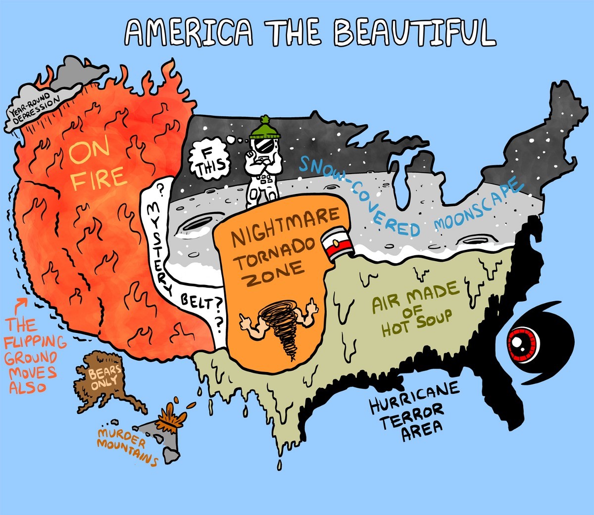
#in what goddamn universe is *New Jersey* #land of 100F-for-weeks-on-end summers #where it can easily be Boxing Day by the time you have (just barely) enough snow to leave a footprint in #where it rarely goes much below 20F #a snow-covered moonscape #like maybe compared to fucking Georgia or something but that’s not exactly *saying* much #home of the brave #maps